New Series of work 2018
- Carol Anne Jones

- Dec 9, 2018
- 4 min read
Updated: Aug 24, 2020


New series just been completed and explanation below. Now on to my next 2019 one.
A “Commodity” is defined as any useful or valuable thing, especially something that is bought and sold.
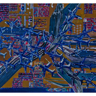
The “Commodities series” focuses on the transportation of these useful, valuable things; everyday products and objects across distances and borders. At the heart of the “Commodities” is the notion that high speed travel and transport networks have fundamentally changed the way humans relate to space and time, and that perceptions of distance between points in space have shortened. The artworks in “the Commodities” feature the symbols of contemporary long and short haul transport networks from land freight to maritime routes, airline systems and services. There are cargo ships, planes, trains and stationary goods in containers awaiting collection; visual symbols of objects and people in continuous motion across very busy international spaces actively participating in the evolving process of globalisation.
International transportation networks are referred to as the enabling factors in the globalization process, not the cause, a condition without which globalisation could not have occurred. Of course humans have been trading for centuries and maritime trade is not a new concept; however the shipping of mass quantities of goods is, and began with the introduction of the shipping container. The first voyage of a standardised container ship named “Ideal X”, set sail from Newark, New Jersey to Houston, Texas in 1956 and was owned by Malcom McLean’s Pan Atlantic Steamship Company. This voyage reshaped the world’s commercial economy by demonstrating that shipping costs could be lowered dramatically. Why? Simply because prior to this virtually all goods were shipped around the world loosely in the holds of ships, but with the intermodal container, wasted space was eliminated and ships could carry more cargo. Loading times were cut by up to three weeks as the containers could easily be loaded onto road and rail networks onward to their destination points. Those “super stretched supply chains” soon followed as goods were transported and transferred between ships, trucks and trains quickly, cheaply and seamlessly, making the humble container the superhero behind that cheap T-shirt and that reasonably priced television.
With increasing world-space movements and flows, collective perceptions of travelling distances changed too, particularly because of the developments in the low cost high speed aviation sector. The metropolitanisation process beginning in the 1990s was integral to air travel expansion as it necessitated multimodal connections via international airports (air platforms) and ever higher bandwidths within digital networks. Cities vied for the top positions in the Global Cities Index by generating good air connectivity and ease of travel to other global cities.
The visual impetus for “Commodities” emerged during one of those all too common long haul flights while watching the “Air show” on the flight entertainment system. The majority of mid to long haul flights have them now, and they display a moving map which is a type of navigation system that displays the aircraft's current location at the centre of the map. The current location is symbolized by a picture of the plane you’re sitting in. As the aircraft continues on its journey towards its destination point, new coordinates are determined. The symbol of the plane representing the current location remains stationary on the display screen while a map or chart image moves beneath. The portrayal typically shows a simulated overhead view of the plane and its location on the moving map, the type of accustomed overhead view seen from the vantage point of a drone or satellite. The air show then also simulates a three-dimensional view from the perspective of the plane. Many systems also go on to show a stationary map image while the location symbol moves to represent the physical movement of the plane. During the air show the map also displays the elevation of the plane above sea level or the earth's surface with the option of exterior camera views of the front, rear and underside of the plane, enabling the passenger to view their flight landing, taking off and cruising.
Topographic maps are accurate three dimensional visual displays of the Earth’s surface that show the shape of the landscape while Isochrone maps show temporal relations in space by preserving the spatial distances in between. Cognitive maps are subjective interpretations of reality which reflect the world in the way a person believes it to be so with the high probability of physical distortion. The same can be said of time-space maps which are created by transferring the coordinates of a physical map into time and space coordinates to represent the distances between places. The result is not proportional to physical distances like in topographical maps, but proportional to the travel times between them.
“Commodities” is not a visual data project that attempts to visually communicate what is happening in reality, nor does it seek to eliminate subjective interpretation. It is simply visually provoking the examination of the true nature of human reality and perception by referring to the way that the acceleration of economic activities has lead to the destruction of spatial barriers and distance.


Comments